Reaching New Heights
Student researchers study geologic wonders of the American West to help them protect earth’s resources
Posted in: Homepage News, Research, Science and Technology, University
After a summer field program studying the geological wonders of the American West, Kerry Murphy, a senior who will graduate in August with a degree in Earth and Environmental Science, says she’s now prepared to dig deeper to better understand the world beneath our feet.
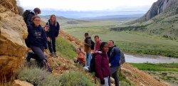
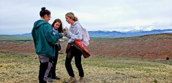
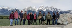
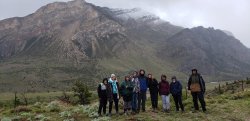
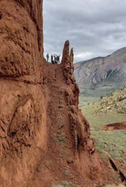
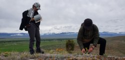
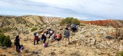
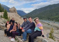
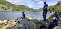
Murphy was among nine Montclair State University students who joined an expedition led by Associate Professor Matthew Gorring in the College of Science and Mathematics’ Field Geology course to study ancient rocks and glaciers for geologic mapping.
“Not only did I get to see some of the most beautiful parts of the country, but I also got to learn about [the Rockies] from a rare and special perspective, a geologic one,” says Murphy. Structural geology, stratigraphy, plate tectonics, geologic mapping and sediment identification – “it’s one thing seeing these geologic structures in a textbook or PowerPoint, but having the opportunity to see them in person gave me a much better understanding of so many concepts.”
The geologic wonders were just part of the experience as the students also discovered the impact of natural disasters exacerbated by human-induced climate change as they explored different areas of the iconic landscapes of Yellowstone National Park, the Grand Tetons, Montana and Wyoming.
The Montclair researchers passed through Yellowstone just days before the devastating flooding. In Red Lodge, Montana, they witnessed the result of wildfires that last summer ripped through Red Lodge threatening the geology field station of the Yellowstone-Bighorn Research Association.
“It’s just uncanny the last two years, we left a few days before these events were happening,” Gorring says.
Montclair’s Field Geology course provides intensive field training with the mapping of the northern Rockies completed by the students shared with the Bureau of Land Management for geological purposes. Before heading west, the group conducted research closer to home, the wetlands in Alonzo F. Bonsal Preserve on the Montclair-Clifton border. Students examined the soil and groundwater flow, with the environmental geology and hydrology research shared with the preserve.
“Sometimes the terrain is pretty tough, particularly out West,” Gorring says, “but the students figure out how to get by.”
It’s all part of the learning that will help the student researchers in their future work as scientists equipped to address climate change, identify contaminants in the environment and develop effective methods for eliminating contaminants from the air, water and soil.
Gallery
Photos shared by Matthew Gorring show the spectacular beauty of their summer laboratory.
Story by Staff Writer Marilyn Joyce Lehren
You May Also Like: