Using Drones to Assess New Jersey Floodplains
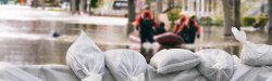
Earth and Environmental Studies Professor Robert Taylor has received a $195,953 grant from the U.S. Department of Defense to further his research on flooding risks and vulnerable housing in the floodplains of Passaic County.
While conducting research for Passaic County, Taylor and his students at the Center for Environmental Management and
Analysis (CEMA) noticed that the traditional sources of elevation information, such as U.S. geographic information system (GIS) maps, do not provide the detailed information that the county needs to make floodplain management decisions.
“If you elevate a building using inaccurate elevation data, it may not make that home less vulnerable to flooding.”
The Office of Planning in Passaic County has requested more detailed information in order to access FEMA maps and to allow communities to become members of the National Flood Insurance Program’s Community Rating System, a voluntary incentive program that encourages communities to reduce floodplain vulnerability. These ratings can also result in lower costs for floodplain insurance. More precise data can impact housing buyback decisions as well as how much to elevate existing housing.
“If you elevate a building using inaccurate elevation data, it may not make that home less vulnerable to flooding,” says Taylor.
The grant will go toward purchasing two unmanned aerial vehicles (UAVs), familiarly called drones, that will provide detailed information on contour elevation and impervious surfaces (like roads and parking lots). The UAV contour maps can estimate elevation at three-centimeter intervals as opposed to three meters. “If you’re in a flood zone, that makes a big difference,” says Taylor.
The lightweight drones have a wingspan of about four feet and can carry two to three pounds of sensors. They will utilize LIDAR technology (which uses lasers to measure distances) and hyperspectral instrumentation (creating thermal imagery) to create 2D and 3D high resolution maps.
Students will receive in-the-field experience and be trained in using drones for environmental research. “Drones are the future,” says Taylor, “and we need to educate our students with practical applications of their use.”
A broader goal of the research is to provide a set of “best practices” for the purchase, relocation and reuse of land in highly vulnerable flood zones in the U.S. and globally — and Taylor is working toward setting up similar research programs with universities in the Philippines and Vietnam, where large cities are subject to flooding.