
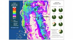
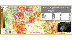
- Forest Aboveground Biomass in the Southwestern U.S. From MISR and GEDI: Assessment with Nasa Carbon Monitoring System DataNew original study published in Remote Sensing of Environment: Forest Aboveground Biomass in the Southwestern U.S. From MISR and GEDI: Assessment with NASA Carbon Monitoring System DataThursday January 15, 2026
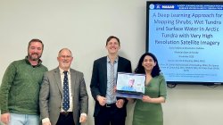
- A Deep Learning Approach for Mapping Shrubs, Wet Tundra and Surface Water in Arctic Tundra with Very High Resolution Satellite ImageryPh.D. candidate Darko Radakovic, advised by Dr. Mark Chopping successfully defended his doctoral dissertationFriday November 21, 2025
- Manuscript in reviewRadakovic, D., Chopping, M., Cook, B., Varde, A.S., and Robila, S. (2026)Thursday November 20, 2025
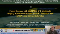
- Forest Biomass with the NASA, JPL MISR: Validation with NASA Lidar-Derived EstimatesDr. Mark Chopping presents a Sustainability Seminar TalkWednesday July 30, 2025
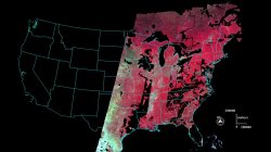
- Two Decades of Changes in Forest Biomass in the Contiguous United States from NASA’s Multiangle Imaging Spectro-RadiometerSpring 2025 Sabbatical Project Progress for Dr. Mark ChoppingWednesday July 30, 2025
- Research Presented at Multiple NASA MeetingsWednesday July 5, 2023
The Remote Sensing Laboratory is located in the Department of Earth and Environmental Studies (EAES). Research activities in the lab are sponsored by NASA. Current projects to use data from NASA’s Earth Observing System satellite instruments to map forest and shrubs in desert grasslands in the southwestern US and in Arctic tundra.
Previous projects sought to exploit data from the Compact High Resolution Imaging Spectrometer (CHRIS) flown on the Proba satellite (sponsored by the European Space Agency).
A research focus is the use of data from the unique NASA/JPL Multiangle Imaging Spectro-Radiometer (MISR), including cutting-edge work on mapping canopy height as well as crown cover; and mapping woody plant cover and community type in desert grasslands and Arctic tundra.
The Lab’s members have included faculty, post-doctoral research associates, and graduate and undergraduate students.
Relevant courses include
- EAES 311 Fundamentals of Remote Sensing of the Environment (undergraduate)
- EAES 511 Fundamentals of Remote Sensing of the Environment (graduate)
- EAES 611 Advanced Environmental Remote Sensing and Image Processing (graduate)
- EAES 210 Introduction to GIS and Remote Sensing (2 hours lecture, 2 hours lab )
- EAES 310 Geographic Information Systems (GIS) (3 hours lab)
- EAES 410 Advanced Topics in GIScience (3 hours lecture)
- EAES 610 Spatial Analysis
- EAES 710 Advanced Geographic Information Systems
- Graduate Certificate Program in Geographic Information Science
- Independent Study at various levels.
Research
- Changes in Shrub Abundance and Albedo in Arctic Tundra…
- Changes in Shrub Abundance in Arctic Tundra…
- Forest and shrub mapping with NASA EOS multiangle remote sensing data (MISR, MODIS)…
Click to zoom:
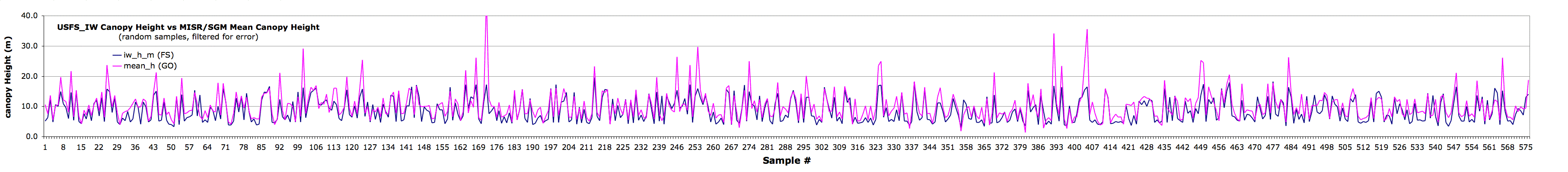
Purple line: MISR/SGM forest canopy height (m)
Blue line: US Forest Service Canopy Height (m)
random samples, screened for topographic shading
It’s important to note that the Forest Service and MISR/GO maps were made using completely different methods. The MISR/GO estimates of fractional woody plant cover and canopy height are not calibrated or scaled, relying only on the geometric-optical model adjusted against MISR data.
- Mapping Carbon Pools in Desert Grasslands using EOS Multi-Angle Data
- Physical Structure of Desert Grasslands using Multiple View Angle Data from CHRIS
- Dramatic Changes in Urban Area in Inner Mongolia:
- Multi-angle remote sensing from the air and associated field data
- BRDF Applications in Semiarid Grassland Monitoring with the AVHRRs
Support
- NASA Earth Observing System (EOS)
- NASA Terrestrial Ecology Program
- NASA LCLUC program
- European Space Agency CHRIS-PROBA Mission