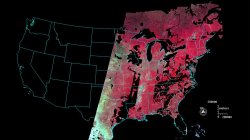
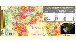
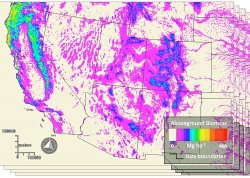
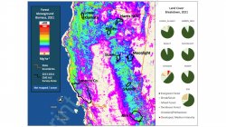
Sunset from orbit

News

All Articles

AGB Change in 2022 over 2000 in Northern California

Research Presented at Multiple NASA Meetings

mapping techniques, using the detection approach

Research Presented at 9th ABoVE Science Meeting (ASTM-9)

Held in San Diego, California, January 23-26, 2023

drought map and it's impact on wildfires in those areas

Tracking forest biomass and disturbance with NASA’s MISR

Dr. Mark Chopping, Professor, Earth and Environmental Studies, and colleagues have published NASA-funded research to map aboveground biomass and disturbance in southwestern forests using multi-angle imaging.

Darko Radakovic

Lab welcomes PhD student Darko Radakovic

Satellite photo of coastal town

Satellite Eye on Earth

Glaciers melting, dust storms raging and typhoons blowing – all captured by NASA’s Earth Observatory satellites each month

Satelite image of coastal sandbars

NASA Earth Observatory

Images and information from the NASA Earth Observatory

aboveground biomass maps

News and Resources in Remote Sensing

Bao Gang

Remote Sensing Lab Research Update – Bao Gang

Variability of Vegetation Net Primary Productivity on the Mongolian Plateau 1982 – 2010 and its Response to Climate Change

photo of river and tributary and enhanced photo showing tree coverage

Remote Sensing Lab Research Update – Phillip Gomez

A High-Resolution Delineation of the Circumpolar Taiga-Tundra Ecotone

above program logo

Our proposal to NASA’s ABoVE program has been selected!

Changes in Shrub Abundance in Arctic Tundra from the Satellite High Resolution Record for the Arctic-Boreal Vulnerability Experiment and Impacts on Albedo

Earth from Orbit 2014

NASA Launches Soil Moisture Mapper