
[PROJECT] Mapping Dante: A Study of Places in the Commedia
Posted in: Projects
As an introduction to Mapping Dante you can watch this short video (made by the magazine OMNIA All things Penn Arts & Sciences as a companion to an article on the the project). Below you will find more detailed information on how the map was designed and developed.
Why Mapping Dante
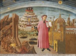
Dante’s Comedy is shaped by the structure of the three realms of afterlife (Hell, Purgatory and Heaven), conceived of according to late medieval geography, cosmology, and theology. Many diagrams and drawings have been made meant to supplement the reading of the poem. Dante’s extreme precision in describing his journey as a living man through afterlife generated a multitude of diagrams and pictures meant to guide readers but also to illustrate Dante’s all-encompassing vision. Yet, the construction of fictional spaces is just one aspect of Dante’s geographical imagination. The path through Inferno, Purgatorio, and Paradiso is full of references to places in the “real” world. The portrait of Dante made by Domenico di Michelino in the cathedral of Santa Maria del Fiore (Florence, 1465) visualizes this two-fold geography by having in the same frame the pit of Hell, the mount of Purgatory, the spheres of Heaven, and the city of Florence: this world and the other, together.
To study Dante’s geographical imagination, we can use a map to visualize of the places he mentions and observe their distribution both in the “real” world” and in the course of his long poem. Hell, Purgatory and Paradise cannot be incorporated into modern cartography (even if they could be marked put on pre-modern maps). What we can translate into a map are the cities, town, regions, mountains, rivers, lakes and seas Dante refers to.
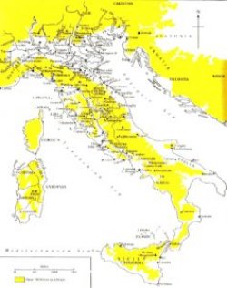
Maps and repertoires of places are not a novelty in Dante studies: the effort of translating his geographical knowledge into spatial representations has been supplementing the reading of the Comedy for a long time. The static nature of traditional maps and lists, however, has limited the potential of literary cartography: on a printed map (or an electronic map based on that model) only a small amount of information can be written, and very few connections can be drawn among a variety of elements. See for examples this map of Dante’s Italy from Charles Singleton’s commentary of the Inferno (click to enlarge). Other examples are available on the website The World of Dante.
Digital tools give us the opportunity to create visualizations that are multi-layered and dynamic. A text can be approached from a variety of angles, with different combinations of close and distant reading, of qualitative and quantitative analysis. The text remains the center of the readers’ experience, but its discourse can branch off into a wider range of forms and directions. Digital literary mapping is one of them: it can enhance our approach to a text (or a corpus of texts) by extracting a network of references which, in turn, become part of the larger network of the “real’” world’s geography. This is not an automatic process: the task of a digital humanist working with literary maps is precisely to use cartography as an opportunity to explore the texts and ask them new questions (or ask old questions in a different way). At the same time, the potentialities and limitations of digital tools must be adapted to the structural and historical configuration of texts.
So what could be a possible effective way to write into a map the geographical data inscribed into a text such as Dante’s Comedy, whose narrative does not travel the surface of the real world and yet constantly refers to its landmarks? What could be the shape of a cartographic repertoire of a medieval literary text for XXI-century readers constantly turning from a printed page to a digital screen and back?
Here comes the idea of Mapping Dante. With this interactive digital map, the first of its kind, users are able to visualize and sort places according to a number of literary, cultural, and geographical categories, in order to explore the connections between Dante’s text and geography. The map allows both distant and close reading of the mentions of places in the Comedy: on one hand it displays their overall distribution within an extent that goes from Scandinavia to Africa, and from Gibraltar to the Urals; on the other hand, the specificity of map layers and the information included in pop-up cards describe in detail each Dantean reference to a place.
Dataset
The first step was to compile a list of all the geographical references in Dante’s Comedy. Taking note of every city, town, region, mountain, lake, river and sea mentioned over the poem’s 100 cantos, I put together a total of 340 items and 724 mentions. Commentaries, both ancient and modern, have been essential to the identification of places, which are not always clearly identifiable on a map, for a number of reasons (ambiguity of textual reference, ambiguity of identification in Dante’s time, destruction of a place, etc.). When multiple identifications are possible (i.e. “Tambernicchi” in Inf. 32.28), or when the reference is irremediably vague in cartographical terms (i.e. “montagne Rife” in Pur. 26.43), I looked for the most reasonable approximation in light not only of Dantean commentaries but also of gazetteers and repertoires out of the field of Dante Studies.
Constructing the spreadsheet of my database was an exercise in close reading. Any mention has been described through a series of categories which later served as a basis for the configuration of the map: kind of geographical item (specific places like towns or mountains, extended areas like regions of different scale and mountain ranges, and waters like rivers, seas and lakes), historico-cultural aspects (visited by Dante, classical, mythological, biblical), and rhetorical features (mention by periphrasis, adjective, simile or direct speech). For each entry I also took note of its cantica, canto and line, and transcribed its terzina both in the original Italian text and in the English translation (I chose to quote from Robert Durling’s version, clear in its prose and handy in its paragraph divisions corresponding to the original terzine).
When it comes to the yes/no logic of computing, it is not always possible to account for nuances and ambiguities that lie within the real world or in the literary text. The classification of a place as classical or mythological, for instance, cannot be automatically applied to all of its mentions: that is the case with Rome, which may be recalled in classical/mythological terms but also as a post-classical/medieval place. Or how can a river be referred to as classical? My strategy was to read it as “classical” only when mentioned in a clearly classical context (as it happens for example in Inf. 20 or Par. 6). The very division between regions “large”, “medium”, and “small” is a practical compromise between the fluidity of medieval geography and need for differentiating the regions’ proportion. Striving for the best approximation is often the rule. In the case of places “visited by Dante” I had to deal with scarce historical documentation and some hypotheses of greater or lesser uncertainty, mostly following biographical evidence provided in Giorgio Inglese, Vita di Dante. Una biografia possibile (Roma: Carocci, 2015) and in the entries of the Enciclopedia dantesca (Roma: Istituto dell’Enciclopedia Italiana, 1970).
Map-Making
The map was built through ArcGIS, a powerful and versatile GIS (Geographical Information System) software. The reason to choose it among various GIS options available today was it allows for high number of manageable layers as required by the project. The map was started with the Desktop version of ArcGIS, and then fully developed and finalized on the platform of ArcGIS Online, with a free public account. I made a point of building Mapping Dante as a low-cost project, the outcome of which depended on experimentation and design more than on an abundance of resources. Choosing to use a free version of the software posed some technical limitations, though: some have been overcome with effective workarounds, some other are still been worked on. The current version of the map includes everything except for rivers, lakes and seas, which will be added later. A look at the layers of Inferno, Purgatorio and Paradiso on the map will show that, while specific places like town and mountains are marked by a pin that gives an adequate idea of their limited extension, larger areas (from small valleys to large territories) are marked by a circle which obviously does not approximate their real extension: the reason is two-fold, technical (the fractal nature of many borders would have consumed more than the amount of memory available to the map) and geo-historical (boundaries in medieval Europe were incomparably more ambiguous and fluid than today, thus not suitable to the precise identification protocol required by GIS-based mapping).
The layers of the map correspond to the descriptors included in the pop-up cards of each mention of a place. Every layer offers an overall view of the distribution of a feature; every marker on a layer on speak about a place and its mentions. To know more about the options allowed by the map, please read the instructions about navigating the map.
Graph and Charts
Further visualizations of the dataset are possible. to enhance the user’s experience in her/his exploration of the geographical encyclopedia of Dante’s Comedy. For now the website of Mapping Dante include a graph and a set of chats that translate in a different way the contents of the map. The graph visualizes the network of relations between places and cantos (in the network, places and cantos are represented as nodes: every time a mention occurs, a connection is drawn, with a node’s size proportioned to its number of connections). and gives visual priority to the geographically densest cantos and to the most frequently mentioned places. The charts offer additional representations of places and cultural/rhetorical features according to quantitative criteria.
Text
Pop-up cards on the map contain only a terzina: more text would not be easily readable. Yet, to make sense of a mention in a specific passage it might be essential to have access to a larger portion of text. This is why I have added to the site the complete Italian text of the 100 cantos of the Comedy. It can be accessed from the “Link to Canto” entry from the map pop-ups (directed to a specific canto and line), or it can be browsed from the Text section. Before the beginning of each canto there is a list of places mentioned; clicking on one of them will lead you to the specific passage,
Andrea Gazzoni
Updates & News
- May 2016: launch of map and website.
- October 2016: complete text of Inferno, Purgatorio and Paradiso with links to passages where places are mentioned.
- November 2016: page with links to online resources about Dante and digital mapping.
- December 2016: short video and article introducing the project (compiled and published by OMNIA All things Penn Arts & Sciences).
- January 2017: paper “Digital Mapping of Dante’s Comedy through Its Place-Names: An Experiment in Literary Geovisualization” presented at the MLA Convention, Philadelphia, January 5-8 (session: Digital Editing and Medieval Texts).
- February 2017: Mapping Dante is awarded the 2016 Digital Project Prize of the Delaware Valley Medieval Association. Presentation of the project at the DVMA’s 2017 Winter Workshop, Rutgers University, New Brunswick, February 25.
- December 2017: article “Mapping Dante: A Digital Platform for the Study of Places in the Commedia” published in Humanist Studies & the Digital Age 5 (2017): 82-95.