
Remote Sensing Lab Research Update – Phillip Gomez
A High-Resolution Delineation of the Circumpolar Taiga-Tundra Ecotone
Posted in: Research
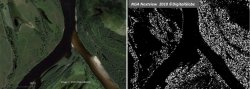
In October 2015 Glen Ridge native and Dartmouth College student Phillip J. Gomez was engaged to assist Montclair State University professor Mark Chopping in completing the University’s contribution to a multi-institution NASA research project: “A High-Resolution Delineation of the Circumpolar Taiga-Tundra Ecotone” (Principal Investigator: K. Jon Ranson, NASA Goddard Space Flight Center; Co-investigators: Chris Neigh (GSFC), Paul Montesano (SSAI/GSFC), Joseph Sexton and Saurabh Channan (University of Maryland, College Park), and Mark Chopping (Montclair State University). The circumpolar Taiga-Tundra Ecotone is subject to accelerated warming and location and structure are changing – but we need to do careful higher resolution analysis to understand impacts of these changes, therefore this project uses airborne and high resolution satellite imagery (HRSI) to evaluate and extend a Landsat 7 vegetation continuous fields product. Montclair State University is contributing high resolution tree maps constructed using Professor Chopping’s CANAPI (Canopy Analysis with Panchromatic Imagery) code – implemented over the summer of 2015 on NASA’s multi-processor cloud computing facilities – to interpret imagery from the DigitalGlobe WorldView sensors. This is available to NASA investigators under a National Geospatial-Intelligence Agency (NGA) NextView license.
Phillip is studying Geography and Government, with a focus in GIS. He brings experience in ArcGIS, QGIS, Computer Aided Design, and Python and also has outstanding achievements in Track & Field. He is assisting with the evaluation of results from over 600 CANAPI runs on large images, with millions of trees mapped. The results will be submitted in an upcoming report to NASA; they will also shed light on techniques to be used in a new NASA-funded project at MSU: "Changes in Shrub Abundance in Arctic Tundra from the Satellite High Resolution Record for the Arctic-Boreal Vulnerability Experiment and Impacts on Albedo”, part of NASA’s ABoVE project (http://above.nasa.gov). This research is supported by NASA’s Carbon Cycle Science and Land Cover Land Use Change programs.