Sunset from orbit

News

Category: Uncategorized

Darko and his dissertation committee

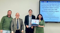
A Deep Learning Approach for Mapping Shrubs, Wet Tundra and Surface Water in Arctic Tundra with Very High Resolution Satellite Imagery

Ph.D. candidate Darko Radakovic, advised by Dr. Mark Chopping successfully defended his doctoral dissertation

Satellite photo of coastal town

Satellite Eye on Earth

Glaciers melting, dust storms raging and typhoons blowing – all captured by NASA’s Earth Observatory satellites each month

Satelite image of coastal sandbars

NASA Earth Observatory

Images and information from the NASA Earth Observatory

aboveground biomass maps

News and Resources in Remote Sensing