
July 30, 2025
Two Decades of Changes in Forest Biomass in the Contiguous United States from NASA’s Multiangle Imaging Spectro-Radiometer
Spring 2025 Sabbatical Project Progress for Dr. Mark Chopping
Posted in: Research
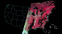
- Goal: To generate forest aboveground biomass maps for the lower 48 states for 2000 – 2022. Maps for the southwest are already published at the Oak Ridge National Lab DAAC and MISR mapping performance assessed using lidar-based estimates. The map series shows forest growth and losses from wildfires, bark beetle, pathogens, storm damage, and harvest.
- Retrieved and processed data (~5,000 – 10,000 files per year) and composited to remove cloud contamination and non-land data, as shown (right). Data to fill the holes have been acquired and processed and are ready for compositing.
- Only two more steps are needed for the production of the complete forest map series for the conterminous United States.