Tracking forest biomass and disturbance with NASA’s MISR
Dr. Mark Chopping, Professor, Earth and Environmental Studies, and colleagues have published NASA-funded research to map aboveground biomass and disturbance in southwestern forests using multi-angle imaging.
Posted in: CSAM Research, Earth & Environmental Studies
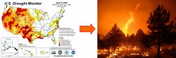
Climate warming and drying are leading to more frequent, extensive, hotter, and more destructive wildfires in the needeleaf forests of the arid southwest: instead of just clearing out undergrowth, the trees are killed and soils are seared, making it harder for saplings to take root and increasing runoff.
Interactions between people, forests, and the climate can result in a rapid flip to a new stable state that is far less friendly to people and has impacts much further afield: in recent years, smoke from western wildfires has started to impact the air in our region; see this July 2021 MSU news article. Scientists also want to know how much carbon is lost (or gained) in forests over time, so we use remote sensing from satellites to map forest aboveground biomass (AGB, units: Mg ha-1).
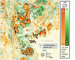
In 2000 NASA launched a satellite called Terra that carries five instruments, including the Multi-angle Imaging Spectro-Radiometer (MISR) that has nine cameras viewing at different angles and in four wavelengths (blue, green, red, and near-infared). A ratio of measurements of reflected red light from MISR provides a multi-angle index that yields more precise AGB estimates than single-angle multispectral imagery. Below, a subset shows the net change in forest AGB 2000-2015 for part of northern California.
This work is reported in Remote Sensing of Environment (Impact Factor: 10.2). The dataset has also been extended to 2021 and published at the Oak Ridge National Laboratory Distributed Active Archive Center. We hope the map series will help ecologists and foresters to improve our understanding of the changes being seen in southwestern forests; and how the progression of these changes might affect people living in this region in the coming decades as the regional climate warms and dries.